
History of the Project
- Home
- The Project
- Photographic Archive
- Heritage Trail
- Oral History
- Church Project
- Mapping Project
- Documents Archive
- Merchandising
- Links

Shortly after learning that the bid had been successful, David contacted an aerial photography firm based at Tollerton in November 2006 to discuss the requirements.
.jpg)
DAVID COOK BRIEFS THE PILOT ON HOW THE AERIAL PHOTOGRAPHS SHOULD BE TAKEN
Though the best time for pictures to be taken was said to be late April or early May, frequent cloudy conditions initially prevented the flights, followed by a series of deluges. So it was early July before conditions were anywhere near good enough and even then there was frequent cloud cover. David briefed the pilot on the angle and height he wanted the pictures taken from.
.jpg)
ONE OF THE FOUR AERIAL PHOTOGRAPHS ON WHICH THE ARTWORK WAS BASED
Four of the eighteen photographs taken were selected as a basis for the illustration and enlarged sufficiently to work from ; even so, a magnifying glass was frequently used. The creative process was very detailed and painstaking, involving first transposing the photographs into a drawing, and then checking and rechecking the perspective before putting paint to paper. The final painting in watercolours, took around 90 hours, being finally completed in February 2008.

POPLARS FARM AND OLD CHAPEL LANE

THE PADDOCKS AND THE GREEN
The text for the Trail Map, prepared by Robert Hartley after the trail had been walked and sketched out, had to be drastically reduced in length so it would fit onto the leaflet. Meanwhile Richard Brooks took a series of photographs of the proposed battlefield trail, some of which were intended for inclusion in the leaflet.
.jpg)
ELSTON HALL AND THE OLD RECTORY

THE MILL AND LINEHAM HOUSE FARM
While the trail map for the village trail progressed satisfactorily, the battlefield trail could not be finalised as easily. The decision had been taken, after many years, to replace the A46 with a dual carriageway which cut across the planned trail route. Further delay was caused by the need for a Public Enquiry leading to uncertainty as to the final route the new road would take. In addition there was an application for an old public right of way across the battlefield to be opened up again, with the possibility of better access than the planned trail would have allowed. The Heritage Lottery Fund responded favourably to a six month extension to the end of July 2010 to accommodate the delays.

MANOR FARM AND CHAPEL FARM
Taking all this into account a decision was made to abandon the idea of a double sided map and to publish two separate maps, which would enable the much earlier publication of the village trail. Copies of the leaflet were made available at Newark Public Library, The Millgate Museum, The Gilstrap Centre in Castle Street, Newark, and from Elston Community Shop. At the time of the Second Exhibition in May 2010, while the final route of the A46 had been decided and construction work had begun, the prospect of the reopened right of way had yet to be realised. The Heritage Lottery Fund again allowed a further two months' extension to the end of September 2010 in the hope that the right of way might materialise.
.jpg)
HALF OF THE REVERSE SIDE OF THE TRAIL MAP
By August 2010, however, Nottingham County Council indicated that there was no prospect of reopening the old footpath across the battlefield. Without this there was nowhere on the proposed trail from which a suitable overview of the battlefield could be seen. The new configuration for Lodge Lane did not include footpaths nor was a pedestrian crossing planned for anyone wishing to cross the existing A46 to reach the bridleway to the Trent. In the circumstances it was not considered wise to encourage people to make the walk and plans for the battlefield trail were therefore abandonned. An interpretive board was however retained in the plan which would be situated at the highest point of the existing public footpath from Lodge Lane to Syerston, whence a good view over the battle site could be obtained.
In June 2018, Nottinghmashire County Council opened a battlefiied trail marked with a series of interpretive boards so that the Elston Heritage Project plan for its own trail has been rendered unnecessary. For information see the following link: https://www.nottinghamshire.gov.uk/culture-leisure/heritage/battle-of-stoke-field
Old Chapel Path
It was a condition of the Lottery grant that all parts of the trails should be accessible to wheelchair users and young children. One of our two oldest buildings, The Old Chapel, was an essential feature of the Village Trail as well as being used for the annual Rogation and carol services, so access to it had to be improved. The field in which it is situated became waterlogged and churned up by horses, particularly the area around the gate which is on a public right of way and becomes a sea of mud in wet conditions, restricting its use and deterring visitors and being a long standing cause for complaints to the Parish Council. The Lottery grant application was therefore a very opportune means of finally solving the problem which hitherto had been too costly for the Parish Council to contemplate.
.jpg)
DAVID COOK AND ROBIN ROSS MEET DAWN WHITTON OF THE CHURCHES CONSERVATION TRUST AT THE OLD CHAPEL
Elston Parochial Church Council, the Southwell Diocese, and the Churches Conservation Trust, which owns the Chapel, all agreed the need for a path but the Trust’s architects were concerned that the appearance of a hard surface ‘pointing’ directly at the building, would ruin the rural appearance of its setting – which is one of its greatest charms. The solution was a tough plastic material, green in colour, resistant to horses’ hooves and ultra violet light which would ‘disappear’ beneath the turf within a few months of being laid and provide a firm sub-surface for pedestrians and wheelchair users in all conditions. The area immediately around the gate where the water collected was laid with the same material and which again would also hardly be visible after a while. The path was finished in June 2009 and at the same time a new gate was installed to make wheelchair access possible.
.jpg)
THE RECENTLY LAID MATRIX IS VISIBLE BUT WILL SOON DISAPPEAR BENEATH THE GRASS
Village Sign
The provision of three village signs was part of the original application. They wre intended to have been positioned on Lodge Lane, Brecks Lane and Elston Lane, all to the same design, facing traffic and pedestrians entering the village. Since the works on the new A46 have resulted in Elston Lane becoming a cul-de-sac the need was reduced to two with a consequent saving in cost.
The Parish Council was also informed that the Highways Agency were highly unlikely to agree to a roadside sign and that in any event they would make no decision on the matter until a year after the completion of the new road. This left the only option of having a single sign within the village itself and it was decided to place the sign close to the Village Hall.
.jpg)
DAVID COOK'S ORIGINAL ARTWORK FOR THE VILLAGE SIGN
Part of David Cook’s brief was to prepare a design and seek quotations for its manufacture. This was a protracted process with unacceptable changes having been made by the contractor as a result of modifying the outline from landscape to portrait. The problems resulted in several reiterations until David Cook was satisfied that the integrity of his original design could be preserved by his own modifications. He added the fine detail of his painting to the contractor's finished sign in his studio before it was signed off for installation.
The design begins on the left a group of archers to commemorate the battle of Stoke (1487) which was fought in both parishes with Elston having an equal claim to its history. The archers are in the colours of the Duke of Oxford (Lancastrian side) ; his troops bore the brunt of the fighting before Henry VII arrived, and the Yorkist army was put to flight. Behind the archers stands the Old Chapel, all that remains of a mediaeval leper hospital, and the parish church of All Saints. Along the back is Elston Hall, the birthplace of Erasmus Darwin whose silhouette is enclosed within the moon above. He was the founder of the Lunar Society, the intellectual powerhouse of the Industrial Revolution whose members included James Watt, Matthew Boulton, Josiah Wedgwood, John Whitehurst, Thomas Day, and Joseph Priestley. They met at the time of the full moon, so that they could travel more safely at night after their meetings. Erasmus has his back to the church, as he eventually rejected formal religion because of his growing belief in a form of ‘natural selection’, with no creator. It was his grandson Charles who actually discovered the mechanism of natural selection.
To the right is the Mill with its sails, which were removed in 1940 as they presented a hazard to low flying aircraft based at nearby Syerston airfield. In front of them are a pair of willow strippers at their posts, with an incomplete basket close to them. The making of baskets and skeps was a cottage industry in Elston until the death of John Rawson in 1959. The two cows and a drover symbolises that Elston was once a dairy village, though in the lifetimes of our current farmers animals have entirely disappeared from Elston farms. Finally, again in the post war years the disappearance of the carthorses – Elston’s last saddler died in 1964 -- and the encroaching mechanisation of farming, are represented by a tractor.
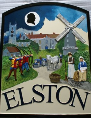
FINISHED SIGN